Idaho Hunt Planner We got game.
Unit 39
- Region 3
- Southwest Region
- Boise River Elk Zone
- Unit 39
Game Management Unit Boundary
Those portions of ADA, BOISE, and ELMORE COUNTIES within the following boundary: beginning at the City of Boise, then southeast on Interstate 84 to Mountain Home, then northeast on the Mountain Home-Anderson Ranch Dam Road to Anderson Ranch Dam, then up the South Fork of the Boise River to Fall Creek (center of Anderson Ranch Reservoir), then up Fall Creek to the Anderson Ranch Reservoir-Fall Creek-Trinity Mountain-Rocky Bar-James Creek Road, then north on Anderson Ranch Reservoir-Fall Creek-Trinity Mountain-Rocky Bar-James Creek Road to James Creek Summit, then east along the watershed divide between the South and Middle Forks of the Boise River to the intersection of the Camas, Blaine and Elmore County lines, then north along the watershed divide between the Boise and Salmon Rivers to the watershed divide between the Boise and South Fork of the Payette Rivers, then west along the divide to Hawley Mountain, then northwest along the divide between the Payette River and the South Fork Payette River to Banks, then south on State Highway 55 to State Highway 44, then east on State Highway 44 to Boise, the point of beginning. THAT PORTION OF ADA COUNTY WITHIN VETERANS MEMORIAL PARK AND THE AREA BETWEEN STATE HIGHWAY 21, WARM SPRINGS AVENUE, AND THE BOISE CITY LIMITS-CLOSED.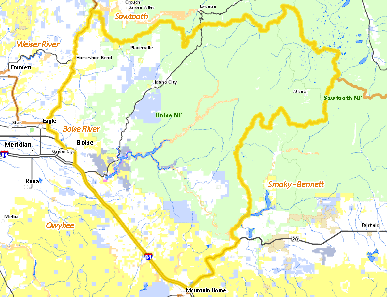
Public Access
Surface Management
For government land, these data show the managing agency of the land, which may or not be the same as the owning agency.
| U.S. Forest Service (USFS) |  58.53
%
58.53
%
|
| Private |
23.22
%
|
| U.S. Bureau of Land Management (BLM) |
9.15
%
|
| State of Idaho |
5.71
%
|
| U.S. Bureau of Reclamation (BOR) |
1.58
%
|
| State of Idaho |
1.33
%
|
| Other |
0.28
%
|
| U.S. Military |
0.17
%
|
| U.S. Corps of Engineers (COE) |
0.01
%
|
| State of Idaho |
0.01
%
|
| Other |
0.01
%
|
Make your own map of Unit 39
Ownership data source: Inside Idaho
Access Yes! Properties
No properties are currently available in Unit 39.
View all Access Yes Participants.
National Forests
Federally-designated Wilderness Areas
No motorized vehicles are allowed in these areas.
-
Sawtooth Wilderness
89,011 acres (5.69% of hunt area)
Land Use/Cover
| Forest |
60.89
%
|
| Rangeland |
36.71
%
|
| Urban |
0.87
%
|
| Irrigated-Gravity Flow |
0.41
%
|
| Dryland Agriculture |
0.35
%
|
| Riparian |
0.27
%
|
| Irrigated-Sprinkler |
0.26
%
|
| Water |
0.23
%
|
Make your own map of Unit 39
Land Use data source: IDWR