Idaho Hunt Planner We got game.
Unit 64
- Region 6
- Upper Snake Region
- Palisades Elk Zone
- Units 64, 65, 67.
Game Management Unit Boundary
Those portions of BONNEVILLE, JEFFERSON, MADISON, and TETON COUNTIES within the following boundary: beginning at the junction of State Highway 33 and U.S. 20 at Sugar City, then south on U.S. 20 to the Lyman-Archer-Heise Road (Snake River Road), then southeast on Lyman-Archer-Heise Road to the Kelly Canyon-Tablerock Road, then east on Kelly Canyon-Tablerock Road to the Hawley Gulch Road (Forest Service Road 218), then east on Hawley Gulch Road to the Hinckley Creek Road (Forest Service Road 213), then east on the Hinckley Creek Road to the watershed divide between Moody Creek and Big Burns Creek, then northeast along the watershed divide between Moody Creek and Big Burns Creek to the head of Hilton Creek, then east along the watershed divide between Big Burns and Canyon Creeks to Garns Mountain, then north along the watershed divide between Canyon Creek and Teton River to Grandview Point, then north down the Milk Creek Road to State Highway 33, then west on State Highway 33 to U.S. 191, the point of beginning.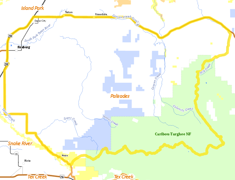
Public Access
Surface Management
For government land, these data show the managing agency of the land, which may or not be the same as the owning agency.
| Private |  70.36
%
70.36
%
|
| U.S. Forest Service (USFS) |
19.54
%
|
| State of Idaho |
9.26
%
|
| U.S. Bureau of Land Management (BLM) |
0.85
%
|
| Other |
0
%
|
Make your own map of Unit 64
Ownership data source: Inside Idaho
Access Yes! Properties
No properties are currently available in Unit 64.
View all Access Yes Participants.
National Forests
Federally-designated Wilderness Areas
No motorized vehicles are allowed in these areas.
There are no wilderness areas in Unit 64.
Land Use/Cover
| Dryland Agriculture |
33.84
%
|
| Irrigated-Sprinkler |
31.97
%
|
| Forest |
23.88
%
|
| Irrigated-Gravity Flow |
6.08
%
|
| Riparian |
2.73
%
|
| Rangeland |
0.99
%
|
| Urban |
0.52
%
|
Make your own map of Unit 64
Land Use data source: IDWR