Idaho Hunt Planner We got game.
Unit 15
- Region 2
- Clearwater Region
- Elk City Elk Zone
- Units 14, 15, 16
Game Management Unit Boundary
That portion of IDAHO COUNTY within the following boundary: beginning at Grangeville on State Highway 13, then northeast on State Highway 13 to the South Fork of the Clearwater River, then downstream to the road that goes up Sally Ann Creek, then up the road to the town of Clearwater, then southeast along Forest Service Road 284 to Forest Service Road 464, then east along Forest Service Road 464 to the watershed divide between the South Fork Clearwater and Selway Rivers, then southeast along the divide over Forest Service Trail 835 to Anderson Butte, then south over Forest Service Trail 505 to Black Hawk Mountain and Soda Creek Point to the Montana Road (Forest Service Road 468), then west on Montana Road to the Red River Ranger Station- Mackay Bar Road (Forest Service Road 222.3), then southwest on Red River Ranger Station-Mackay Bar Road to Dixie Summit, then west along the watershed divide between the South Fork Clearwater and Salmon Rivers over the Crooked River-Big Creek Divide, Orogrande Summit and Square Mountain to the Moores Guard Station-Adams Ranger Station Road (Forest Service Road 444), then west on Moores Guard Station-Adams Ranger Station Road to the Grangeville-Salmon River Road (Forest Service Road 221), then north on Grangeville-Salmon River Road to Grangeville, the point of beginning.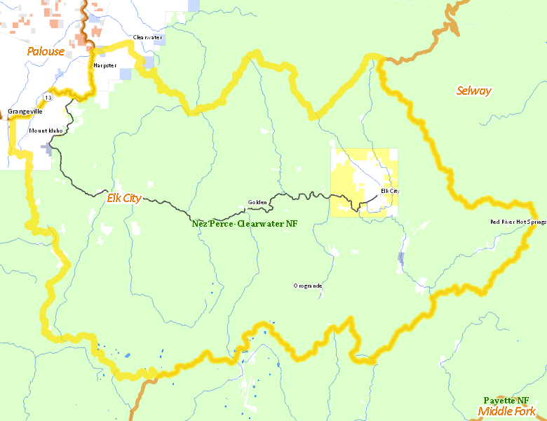
Public Access
Surface Management
For government land, these data show the managing agency of the land, which may or not be the same as the owning agency.
| U.S. Forest Service (USFS) |  90.06
%
90.06
%
|
| Private |
7.25
%
|
| U.S. Bureau of Land Management (BLM) |
2.4
%
|
| State of Idaho |
0.15
%
|
| State of Idaho |
0.12
%
|
| Other |
0.01
%
|
| Indian Reservation / Bureau of Indian Affairs |
0
%
|
Make your own map of Unit 15
Ownership data source: Inside Idaho
Access Yes! Properties
No properties are currently available in Unit 15.
View all Access Yes Participants.
National Forests
Federally-designated Wilderness Areas
No motorized vehicles are allowed in these areas.
-
Gospel Hump Wilderness
66,216 acres (11.82% of hunt area)
Land Use/Cover
| Forest |
96.02
%
|
| Dryland Agriculture |
2.95
%
|
| Irrigated-Sprinkler |
0.95
%
|
Make your own map of Unit 15
Land Use data source: IDWR