Idaho Hunt Planner We got game.
Unit 14
- Region 2
- Clearwater Region
- Elk City Elk Zone
- Units 14, 15, 16
Game Management Unit Boundary
That portion of IDAHO COUNTY within the following boundary: beginning at Riggins on the Salmon River, then upstream to Wind River, then up Wind River to Anchor Creek, then up Anchor Creek to Anchor Meadows, then northeast along the old wagon road (Forest Service Trail 313) to the divide between the Salmon River and South Fork Clearwater River, then west on the divide to Square Mountain, then west on the Square Mountain-Gospel Hill Road (Forest Service Road 444) to the Grangeville-Salmon River Road (Forest Service Road 221), then north on Grangeville-Salmon River Road to State Highway 13 at Grangeville, then west on Highway 13 to U.S. 95, then northwest on U.S. 95 to Cottonwood, then south on the Graves Creek Road to the Salmon River, then upstream to Riggins, the point of beginning. NEZ PERCE NATIONAL HISTORICAL PARK-CLOSED.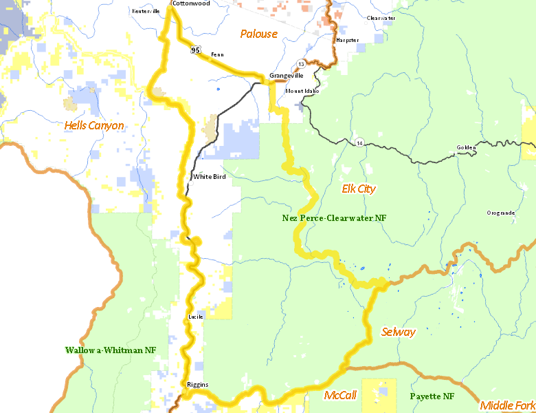
Public Access
Surface Management
For government land, these data show the managing agency of the land, which may or not be the same as the owning agency.
| U.S. Forest Service (USFS) |  59.27
%
59.27
%
|
| Private |
33.29
%
|
| State of Idaho |
3.89
%
|
| U.S. Bureau of Land Management (BLM) |
2.99
%
|
| Other |
0.54
%
|
| State of Idaho |
0.01
%
|
| U.S. National Park Service (NPS) |
0.01
%
|
Make your own map of Unit 14
Ownership data source: Inside Idaho
Access Yes! Properties
No properties are currently available in Unit 14.
View all Access Yes Participants.
National Forests
Federally-designated Wilderness Areas
No motorized vehicles are allowed in these areas.
-
Gospel Hump Wilderness
27,097 acres (7.38% of hunt area)
Land Use/Cover
| Forest |
69.22
%
|
| Rangeland |
18.64
%
|
| Dryland Agriculture |
12.03
%
|
| Irrigated-Sprinkler |
0.12
%
|
Make your own map of Unit 14
Land Use data source: IDWR