Idaho Hunt Planner We got game.
Unit 52A
- Region 6
- Upper Snake Region
- Big Desert Elk Zone
- Units 52A, 68
Game Management Unit Boundary
Those portions of BLAINE, BUTTE, LINCOLN, and MINIDOKA COUNTIES within the following boundary: beginning at Shoshone, then north and east on U.S. 93 to Arco, then south on the Arco- Minidoka Road to Minidoka, then northwest on State Highway 24 to Shoshone, the point of beginning. CRATERS OF THE MOON NATIONAL MONUMENT-CLOSED.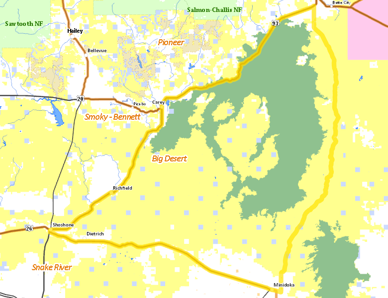
Public Access
Surface Management
For government land, these data show the managing agency of the land, which may or not be the same as the owning agency.
| U.S. Bureau of Land Management (BLM) |  55.47
%
55.47
%
|
| U.S. National Park Service (NPS) |
33.59
%
|
| Private |
8.84
%
|
| State of Idaho |
1.97
%
|
| State of Idaho |
0.05
%
|
| U.S. Bureau of Reclamation (BOR) |
0.04
%
|
| State of Idaho |
0.04
%
|
Make your own map of Unit 52A
Ownership data source: Inside Idaho
Access Yes! Properties
No properties are currently available in Unit 52A.
View all Access Yes Participants.
National Forests
No National Forest lands fall within Unit 52A.
Federally-designated Wilderness Areas
No motorized vehicles are allowed in these areas.
There are no wilderness areas in Unit 52A.
Land Use/Cover
| Rangeland |
60.31
%
|
| Rock |
32.76
%
|
| Irrigated-Sprinkler |
4.66
%
|
| Irrigated-Gravity Flow |
1.85
%
|
| Dryland Agriculture |
0.34
%
|
Make your own map of Unit 52A
Land Use data source: IDWR