Idaho Hunt Planner We got game.
Unit 38
- Region 3
- Southwest Region
- Owyhee Elk Zone
- Units 38, 40, 41, 42
Game Management Unit Boundary
Those portions of ADA, BOISE, CANYON, ELMORE, GEM, and PAYETTE COUNTIES within the following boundary: beginning at the confluence of the Payette and Snake Rivers, then up the Payette River (INCLUDING ISLANDS) to State Highway 52 near Emmett, then south on State Highway 52 to State Highway 16, then south on State Highway 16 to Floating Feather Road, then east on Floating Feather Road to State Highway 55, then south on State Highway 55 to State Highway 44, then east on State Highway 44 to Boise, then south on Interstate 84 to Mountain Home, then south on State Highway 51 to the Snake River, then downstream (INCLUDING ISLANDS) to the Idaho-Oregon State line, then north on the state line to the Payette River, the point of beginning. LAKE LOWELL SECTOR OF DEER FLAT NATIONAL WILDLIFE REFUGE CLOSED.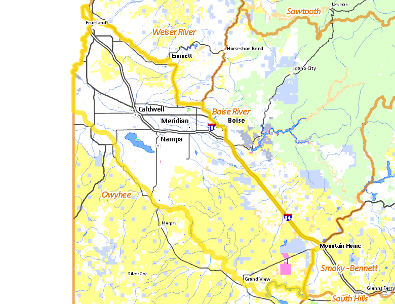
Public Access
Surface Management
For government land, these data show the managing agency of the land, which may or not be the same as the owning agency.
| Private |  59.07
%
59.07
%
|
| U.S. Bureau of Land Management (BLM) |
32.57
%
|
| State of Idaho |
4.65
%
|
| U.S. Bureau of Reclamation (BOR) |
1.29
%
|
| Other |
1.15
%
|
| U.S. Military |
0.61
%
|
| State of Idaho |
0.32
%
|
| U.S. National Wildlife Refuge (NWR) |
0.1
%
|
| State of Idaho |
0.04
%
|
| Other |
0
%
|
Make your own map of Unit 38
Ownership data source: Inside Idaho
Access Yes! Properties
No properties are currently available in Unit 38.
View all Access Yes Participants.
National Forests
No National Forest lands fall within Unit 38.
Federally-designated Wilderness Areas
No motorized vehicles are allowed in these areas.
There are no wilderness areas in Unit 38.
Land Use/Cover
| Rangeland |
46.76
%
|
| Irrigated-Gravity Flow |
35.82
%
|
| Irrigated-Sprinkler |
7.83
%
|
| Urban |
5.62
%
|
| Dryland Agriculture |
2.36
%
|
| Water |
0.98
%
|
| Riparian |
0.61
%
|
Make your own map of Unit 38
Land Use data source: IDWR