Idaho Hunt Planner We got game.
Unit 28
- Region 7
- Salmon Region
- Salmon Elk Zone
- Units 21, 21A, 28, 36B
Game Management Unit Boundary
That portion of LEMHI COUNTY within the drainage of the Salmon River south and west of the river from the mouth of the Middle Fork of the Salmon River upstream to, but excluding, the Ellis Creek and Morgan Creek drainages to the Custer County line, and that portion of the north side of Camas Creek and north of the Camas Creek Trail (Forest Service Trail 134) upstream from and including the Yellowjacket Creek drainage.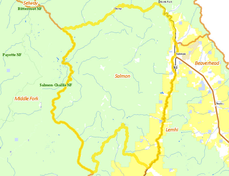
Public Access
Surface Management
For government land, these data show the managing agency of the land, which may or not be the same as the owning agency.
| U.S. Forest Service (USFS) |  87.7
%
87.7
%
|
| U.S. Bureau of Land Management (BLM) |
8.44
%
|
| Private |
3.32
%
|
| State of Idaho |
0.3
%
|
| Other |
0.24
%
|
| State of Idaho |
0.01
%
|
Make your own map of Unit 28
Ownership data source: Inside Idaho
Access Yes! Properties
No properties are currently available in Unit 28.
View all Access Yes Participants.
National Forests
Federally-designated Wilderness Areas
No motorized vehicles are allowed in these areas.
-
Frank Church - River of No Return Wilderness
116,412 acres (13.91% of hunt area)
Land Use/Cover
| Forest |
89.62
%
|
| Rangeland |
8.56
%
|
| Irrigated-Gravity Flow |
1.51
%
|
| Irrigated-Sprinkler |
0.23
%
|
| Urban |
0.07
%
|
| Water |
0.02
%
|
Make your own map of Unit 28
Land Use data source: IDWR