Idaho Hunt Planner We got game.
Unit 8A
- Region 2
- Clearwater Region
- Palouse Elk Zone
- Units 8, 8A, 11A
Game Management Unit Boundary
Those portions of BENEWAH, LATAH, CLEARWATER, and NEZ PERCE COUNTIES within the following boundary: Beginning at Ahsahka on County Road P-1, then northwest along County Road P-1 through Southwick and Cavendish to State Highway 3, then northeast along State Highway 3 to Deary, then northwest along State Highway 9 to State Highway 6, then west along State Highway 6 to U.S. 95, then north along U.S. 95 to the watershed divide between Hangman Creek and Palouse River, then southeast along the divide to West Dennis Mountain, then southeast along the St. Maries watershed divide to Hemlock Butte, then south on Elk Creek Road (Forest Service Road 382.4) to Elk River, then south on the Dent Bridge-Elk River Road to the south shoreline of Dworshak Reservoir, then along the southern shoreline to Dworshak Dam, then downstream along the North Fork of the Clearwater River to Ahsahka, the point of beginning.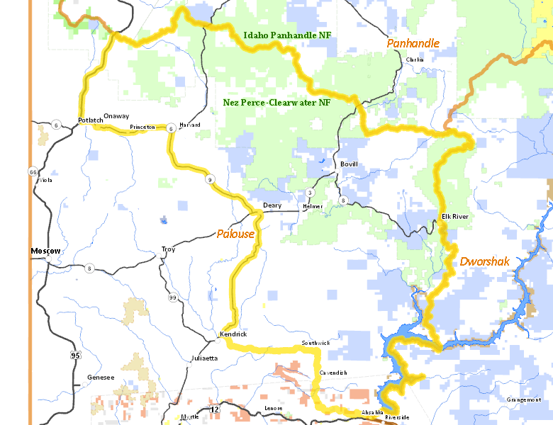
Public Access
Surface Management
For government land, these data show the managing agency of the land, which may or not be the same as the owning agency.
| Private |  59.77
%
59.77
%
|
| U.S. Forest Service (USFS) |
26.65
%
|
| State of Idaho |
12.22
%
|
| U.S. Corps of Engineers (COE) |
0.64
%
|
| Indian Reservation / Bureau of Indian Affairs |
0.43
%
|
| Other |
0.13
%
|
| Indian Reservation / Bureau of Indian Affairs |
0.12
%
|
| State of Idaho |
0.03
%
|
| U.S. Bureau of Land Management (BLM) |
0.02
%
|
Make your own map of Unit 8A
Ownership data source: Inside Idaho
Access Yes! Properties
No properties are currently available in Unit 8A.
View all Access Yes Participants.
National Forests
Federally-designated Wilderness Areas
No motorized vehicles are allowed in these areas.
There are no wilderness areas in Unit 8A.
Land Use/Cover
| Forest |
67.37
%
|
| Dryland Agriculture |
30.86
%
|
| Water |
1.77
%
|
Make your own map of Unit 8A
Land Use data source: IDWR