Idaho Hunt Planner We got game.
Hunt Area
That portion of Unit 24 within the following boundary: Beginning north of Cascade at the junction of State Highway 55 and Warm Lake Road, then north on Highway 55 to West Roseberry Road, then west on West Roseberry Road to Norwood Road, then south on Norwood Road to Tamarack Falls Road, then west on Tamarack Falls Road to West Mountain Road, then north on West Mountain Road to Forest Service Road 186, then northwest on Forest Service Road 186 to No Business Saddle, then south along the Unit 24/32A unit boundary to the intersection of the Unit 24/32A/33 boundaries at Smith’s Ferry, then north along the Unit 24/33/25 boundary to Warm Lake Road, then west on Warm Lake Road to the point of beginning. EXCEPT Short Range Weapons ONLY within the following boundary: Beginning in Donnelly at the junction of State Highway 55 and West Roseberry Road, then west on West Roseberry Road to Norwood Road, then south on Norwood Road to Tamarack Falls Road, then west on Tamarack Falls Road to West Mountain Road, then south on West Mountain Road to Cabarton Road, then north on Cabarton Road to State Highway 55, then north on State Highway 55 to the point of beginning.
More information about the Game Management Unit(s) in this area: 24 24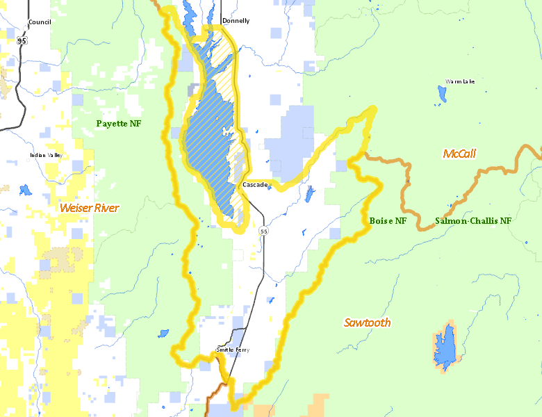
Recent Hunts in this Area
| Year | Tag | Open | Close | Take Method | Game | Area |
|---|---|---|---|---|---|---|
| 2024 | Elk Controlled Hunt 2068 | 10/15/2024 | 11/8/24 | Any Weapon | Elk | Area 24-2 |
Surface Management
For government land, these data show the managing agency of the land, which may or not be the same as the owning agency.
 Private 70.82%
|
|
U.S. Forest Service (USFS) 42.22%
|
|
State of Idaho 6.71%
|
|
U.S. Bureau of Reclamation (BOR) 4.66%
|
|
Other 1.34%
|
|
U.S. Bureau of Land Management (BLM) 0.63%
|
|
State of Idaho 0.57%
|
Make your own map of Hunt Area
Ownership data source: Inside Idaho
Access Yes! Properties
Access Yes! is Fish and Game program designed to improve hunting and fishing access to private land or through private land to public land by compensating willing landowners who provide access.
No properties are currently available in .
View all Access Yes Participants.
Forest Service Land
Check for road and area closures on National Forest websites
Federally-designated Wilderness Areas
No motorized vehicles are allowed in these areas.
There are no wilderness areas in .
Land Use/Land Cover
|
Forest
87.13
%
|
|
Irrigated-Gravity Flow
18.57
%
|
|
Water
9.02
%
|
|
Rangeland
7.9
%
|
|
Riparian
3.69
%
|
|
Irrigated-Sprinkler
0.64
%
|
Make your own map of Hunt Area
Land Use data source: IDWR
Towns in this Hunt Area
- Cascade, Idaho 55