Idaho Hunt Planner We got game.
Hunt Area
All of Unit 54
More information about the Game Management Unit(s) in this area: 54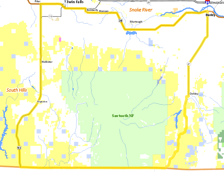
Recent Hunts in this Area
| Year | Tag | Open | Close | Take Method | Game | Area |
|---|---|---|---|---|---|---|
| 2024 | Deer Controlled Hunt 1043 | 11/15/2024 | 11/30/24 | Any Weapon | Mule and White-tailed Deer | Area 54 |
| 2024 | Deer Controlled Hunt 1173 | 11/15/2024 | 11/30/24 | Any Weapon | Mule and White-tailed Deer | Area 54 |
| 2024 | Elk Controlled Hunt 2034 | 10/15/2024 | 11/10/24 | Any Weapon | Elk | Area 54 |
| 2024 | Elk Controlled Hunt 2090 | 10/15/2024 | 11/10/24 | Any Weapon | Elk | Area 54 |
| 2024 | Elk Controlled Hunt 2192 | 10/15/2024 | 11/10/24 | Any Weapon | Elk | Area 54 |
| 2024 | Deer Controlled Hunt 1042 | 10/5/2024 | 10/31/24 | Any Weapon | Mule and White-tailed Deer | Area 54 |
| 2024 | Deer Controlled Hunt 1108 | 10/5/2024 | 10/31/24 | Any Weapon | Mule and White-tailed Deer | Area 54 |
| 2024 | Deer Controlled Hunt 1172 | 10/5/2024 | 10/31/24 | Any Weapon | Mule and White-tailed Deer | Area 54 |
| 2024 | Elk Controlled Hunt 2134 | 9/25/2024 | 10/14/24 | Muzzleloader | Elk | Area 54 |
| 2024 | Elk Controlled Hunt 2191 | 9/25/2024 | 10/14/24 | Muzzleloader | Elk | Area 54 |
| 2024 | Pronghorn Controlled Hunt 4018 | 9/25/2024 | 10/24/24 | Any Weapon | Pronghorn Antelope | Area 54 |
| 2024 | Deer Controlled Hunt 1082 | 8/30/2024 | 9/30/24 | Archery | Mule and White-tailed Deer | Area 54 |
| 2024 | Deer Controlled Hunt 1171 | 8/30/2024 | 9/30/24 | Archery | Mule and White-tailed Deer | Area 54 |
| 2024 | Elk Controlled Hunt 2121 | 8/30/2024 | 9/24/24 | Archery | Elk | Area 54 |
| 2024 | Elk Controlled Hunt 2190 | 8/30/2024 | 9/24/24 | Archery | Elk | Area 54 |
| 2024 | Pronghorn Controlled Hunt 4040 | 8/15/2024 | 9/15/24 | Archery | Pronghorn Antelope | Area 54 |
| 2024 | Pronghorn Controlled Hunt 4056 | 8/15/2024 | 10/24/24 | Any Weapon | Pronghorn Antelope | Area 54 |
| 2024 | Elk Controlled Hunt 2152 | 8/1/2024 | 8/29/24 | Any Weapon | Elk | Area 54 |
Surface Management
For government land, these data show the managing agency of the land, which may or not be the same as the owning agency.
 Private 40.72%
|
|
U.S. Forest Service (USFS) 34.59%
|
|
U.S. Bureau of Land Management (BLM) 22.79%
|
|
State of Idaho 1.76%
|
|
State of Idaho 0.1%
|
|
U.S. Military 0.04%
|
Make your own map of Hunt Area
Ownership data source: Inside Idaho
Access Yes! Properties
Access Yes! is Fish and Game program designed to improve hunting and fishing access to private land or through private land to public land by compensating willing landowners who provide access.
Forest Service Land
Check for road and area closures on National Forest websites
Federally-designated Wilderness Areas
No motorized vehicles are allowed in these areas.
There are no wilderness areas in .
Land Use/Land Cover
|
Rangeland
55.03
%
|
|
Irrigated-Gravity Flow
23.63
%
|
|
Forest
11.58
%
|
|
Urban
4.59
%
|
|
Irrigated-Sprinkler
2.86
%
|
|
Dryland Agriculture
1.76
%
|
|
Riparian
0.53
%
|
Make your own map of Hunt Area
Land Use data source: IDWR